CNN
—
A new tropical system that will eventually strengthen into Tropical Storm Sara is expected soon and is worth monitoring for impacts in the Caribbean, Central America, Mexico and United States.
Powerful, storm-disrupting upper-level winds protected the Gulf Coast from Hurricane Rafael last week, but there could be an opening for tropical trouble to reach the US next week.
It’s another example of an Atlantic hurricane season that hasn’t played by the rules. Tropical activity should be winding down in November, but this will be the third named storm this month instead thanks to exceptionally warm water wrought by climate change.
For now, it’s a fledgling area of stormy weather – dubbed Potential Tropical Cyclone Nineteen – just south of Jamaica, according to the National Hurricane Center.
A potential tropical cyclone is a designation given by the NHC to a system that hasn’t formed yet, but will soon and is expected to bring impacts to land within 48 hours.
It’s forecast to become a tropical depression by Thursday morning and then strengthen into a tropical storm as early as Thursday afternoon. It could eventually become a hurricane as it meanders over the very warm water of the western Caribbean Sea – the same body of water that fueled Rafael. It will then drift toward Central America and stall in the area over the weekend and into early next week.
The storm will bring “life-threatening and potentially catastrophic” flooding rainfall up to 30 inches to Honduras and double-digit rainfall totals to other parts of Central America, the NHC warned.
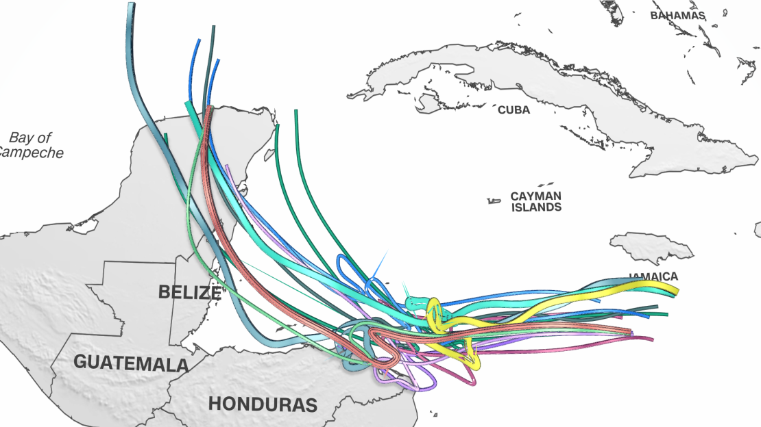
Forecast scenarios diverge drastically beyond Central America and hinge on how close the system gets to the coast. The official forecast from the hurricane center has the system hugging the coast of Honduras over the weekend, but this could change.
There are a few potential scenarios on the table for how formidable the storm could be or whether it could reach the US next week.
It could make landfall in Honduras or Nicaragua this weekend and deteriorate while over land, cut off from the warm water fueling it. This scenario would bring strong winds and a deluge to Central America but could keep the storm away from the US.
A storm that remains very close to the coast of Central America but doesn’t make landfall would still unleash heavy rainfall there and could eventually emerge in the southern Gulf of Mexico next week. It would likely emerge as a weaker storm, which could lessen the blow if it were to reach the US.
But if the system stays just a bit farther off the coast and over tremendously warm water, it could strengthen considerably – and possibly rapidly intensify – while it stalls.
Sea surface temperatures in the Caribbean are currently second-warmest on record – just behind 2023’s record-breaking heat. They’re warmer than they should be at the peak of hurricane season and could continue to produce unusually strong storms. Warmer bodies of water are fueling stronger storms and more rapid intensification as the world warms due to fossil fuel pollution.
It could then make a gradual turn to the northwest, head for Mexico’s Yucatán Peninsula or Cuba and potentially reach the eastern Gulf of Mexico.
The Gulf is record warm for this time of year and likewise could boost or sustain any system that reaches it.
This scenario would slam parts of Honduras, Nicaragua and surrounding areas with torrential, flooding rainfall and damaging winds for days before the system moves away early next week. Mexico’s Yucatán Peninsula or Cuba could be next in line for similar impacts, depending on how strong the system becomes and how sharp of a turn it makes.
This scenario is the most troubling for the US, too. A stronger system in the Gulf of Mexico could make a run at Florida next week.
Five hurricanes have slammed into the US Gulf Coast this year.
If this system were to make landfall in the US it could challenge the latest landfalling hurricane on record. The current record rests with Hurricane Kate, which made landfall as a Category 2 storm in Florida on November 21, 1985.
Hurricane season officially comes to an end on November 30, but named storms have formed in December in the past.
Author :
Publish date : 2024-11-13 03:29:00
Copyright for syndicated content belongs to the linked Source.
Author : theamericannews
Publish date : 2024-11-14 03:32:29
Copyright for syndicated content belongs to the linked Source.
